
Keyword Search
Enter a word or phrase to perform a general search across Object, Photo, Archive, Library, and Container List records.
Search Tips
- Searches are not case sensitive.
- Searching for multiple words connects them with OR by default. Matching records can contain any of the words.
- Connect multiple words with AND if you only want to see records containing both words.
- Use quotation marks to search for a phrase.
- Place an asterisk (*) at the end of a word as a wildcard.
Keyword Search Results
19 results found.
-
Aerial View 1938 - 2004.1.662
Aerial view of Compton gardens (including Compton mansion, Rose Garden, Fernery, English Park) and the surrounding area including Hillcrest Ave., Meadowbrook Ave., Northwestern Ave., Paper Mill Road, Dallin Aerial Survey Company, 1924-1941 Photo dated: October 22, 1938 Credit line: Hagley Museum & Library
Record Type: Photo
-
Aerial View 1983 - 2004.1.659
Aerial view from the Rose Garden to Gates Hall, pre-entrance drive and parking lot 1984
Record Type: Photo
-
Aerial View of Arboretum 1938 - 2004.1.660
Aerial view of Compton (including Compton, Rose Garden, Fernery, English Park) and the surrounding area including Hillcrest Ave., Meadowbrook Ave., Northwestern Ave. & Paper Mill Road. Note: Photo taken after removal of pyramidal roof on mansion tower in 1937. Dallin Aerial Survey Company, 1924-1941 Photo dated: October 22, 1938 Credit line: Hagley Museum & Library. Enlarged closeup of 2004.1.662
Record Type: Photo
-
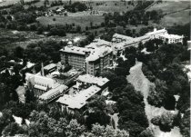
Aerial View of Chestnut Hill College and Bloomifield Farm - 2010.3.29
Aerial View of Chestnut Hill College, with Bloomfield Farm in the upper left corner and center, and a piece of the Arboretum in the upper right corner.
Record Type: Photo
-
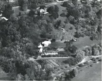
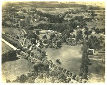
Aerial View of Compton Estate - 2004.1.661.1
Aerial view of Compton Estate (including Compton, Rose Garden, Fernery complex, Swan Pond, English Park) and Chestnut Hill College. The Headhouse is not behind the fernery. Copyright "Airgraph", Aero Service Corp., Philadelphia, Pa. As of 2018, the coyright is owned by Hagley. A larger version of this print is in Map Drawer A at 2004.661.2
Record Type: Photo
-
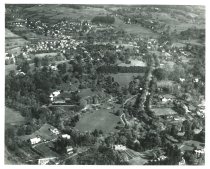
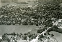
Aerial View of Flourtown West of Bethlehem Pike ca 1960-1970 - 2010.3.1
Aerial View of College Ave, Grove Ave and E. Mill Rd, Bethlehem Pike, Carson Valley School, Orchard Building and Black Horse Inn in Flourtown.
Record Type: Photo
-

-
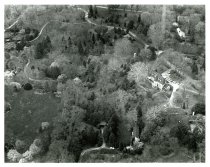
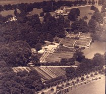
Aerial view of Compton estate - 2013.27.45
Aerial view of Compton estate; mansion upper center; carriage house upper left. Four square garden with formal plantings in 3 squares, rows of fruit shrubs in 4th square. Grape arbor in center of garden. Greenhouse range with Palm House, Mum House, Fernery and hot beds to left of formal garden; orchard and fields below. Note: photograph taken prior to removal of pyramidal roof on mansion tower in 1937 and prior to removal of grape arbor circa ...
Record Type: Photo
-
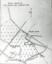
Arboretum Soil Acidity Map cir. 1930 - 2004.1.911LS
Soil Acidity map of Morris Arboretum (soil acidity map -- numbers = ph) cir. 1930 Lantern slide
Record Type: Photo
-
Compton Atlas Title Page 1909 - 2010.16.14
Title page of 1909 Compton Atlas, a four-volume atlas of the property created by Pugh & Hubbard. Notes: Maps record every detail of the estate including land contour, building footprints and plant names. Maps are used in the restoration of the garden.
Record Type: Photo

-
-
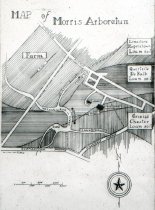
Map of Morris Arboretum and Soil Types cir. 1930 - 2004.1.912LS
Map of Morris Arboretum and its Soil Types aft. 1932 Lantern slide Dr. Wherry was a chemistry professor specializing in soil chemistry, then joined the Botany Dept at Penn, and was appointed to the Arboretum as an Ecologist in 1932.
Record Type: Photo
-
Mill Documents: Photographs & Illustrations, 1939-1990, & undated - 2011.3.15
Photocopy
Record Type: Archive
-
Morris Arboretum Sequence of Land Acquisition - 2010.10.2
Morris Arboretum - Historical sequence of land acquisition by John Morris 1887 - 1917 and the University of Pennsylvania in 1948 after extensive research in local archives. Researched by M. Lloyd
Record Type: Photo
-
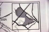
Roads Around the Immediate Vicinity of the Arboretum - 2013.1.256
Map -- Immediate vicinity of the Arboretum
Record Type: Photo
-
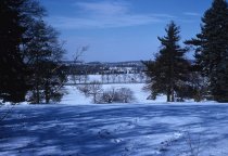
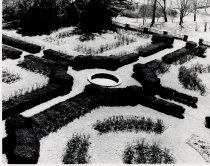
Rose Garden in Winter - 2004.1.458
Aerial view of Rose Garden in winter. Light snowfall covers planting beds. Mature boxwood hedges, all four quadrants of garden planted with roses. No fountain in center.
Record Type: Photo
-
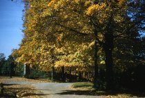
View from Meadowbrook Avenue 1956 - 2013.1.2
View of Sugar maples along Meadowbrook Ave ourside the Arboretum from Meadowbrook Avenue Gate Oct 19, 1956.
Record Type: Photo
-
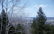
View from Sugar Loaf 1956 - 2013.1.3
View of Arboretum from Sugar Loaf Mar 26, 1956
Record Type: Photo
-
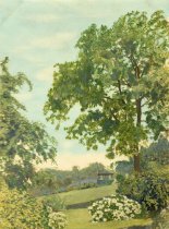
View of Summerhouse circa 1920s - 2004.1.801
A view of gardens around Summerhouse on edge of Rose Garden. Notes: Watercolor. Matted and signed by Mulford Bateman Foster (1888-1978) artist, horticulturist, landscape expert, circa 1920s
Record Type: Photo