

Archive Record
Images


Additional Images [1]

Metadata
Title |
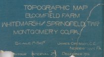
Topographic Map of Bloomfield Farm 1916 |
Object ID |
2018.29.28 |
Object Name |
Drawing, Architectural |
Scope & Content |
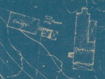
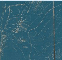
Topographic Map of Bloomfield Farm 1916 Whitemarsh & Springfield Twp by James Cresson, C.E. Norristown plan; blueprint of topographic map showing elevatation Blueprint. Scale 1" = 50' |
Date |
1916 |
Collection |
Drawings |
Year Range from |
1910 |
Year Range to |
1920 |
Internal number |
2018-10-02 |
Catalog type |
Map |